FocusFlite®
Airborne Digital Moving Map System
Turkiye's first and only field proven integrated/mobile digital moving map and mission planning system solution is in use on more than 75 platforms.
FocusFlite GS
One planning solution for all platforms
FocusFlite® GS (Ground Station) helps pilots to review/prepare their mission plans with high precision and accuracy thanks to the 2D/3D planning capabilities it provides for different platforms. With its extensible and adaptable mission planning infrastructure, platform-specific capabilities such as performance calculations can be easily added. Intuitive, fast and responsive human-machine interface of the program has been developed, supported by usability tests.
FocusFlite® GS capabilities can be used on consoles, desktop stations and portable platforms.
![]()
General Capabilities
- Multi-user planning
- GIS developed in-house
- Virtual globe infrastructure
- Modern menu system with toolbar and tabs, expandable tools and dockable UI components, customizable user interface elements
- Big data processing, dynamic data reduction
- Administrative capabilities (different user roles, user authentication, central&local data and crew management, backup etc.)
- Advanced layer management
- Multi language support, UTM, MGRS and geographical coordinates
- Imperial/metric units of measurement, 50+ datum, mission data transfer capabilities
- Map tools (distance, bearing, area measurement) and map marker
- Map printing capability
- Aircraft mission data preparation (navigation, POI, flight plan, magnetic variation, communication etc.)
- Fully integrated with FocusFlite® AS
- Compatible with DO-200 A/B
- Redhat, Debian (Including PARDUS) based Linux operating system support
Mission Planning Capabilities
- Advanced flight planning capabilities (Automatic/Manual IFR, VFR, Cargo and CARP/ HARP planning, flight patterns, navigational information blocks, tactical approaches, take-off / landing procedures (SID, STAR, IAP) and route indicators, terrain following and level flight modes)
- Flight plan analysis and performance calculations (estimated time of arrival, distance, fuel consumption, weight-balance etc.)
- Flight plan reports
- Aircraft/platform configuration, emergency procedures, magnetic variation
- Vertical cross section, terrain, visibility, threat coverage, NOTAM, buffer zone and obstacle analysis
- Communication analysis and planning
- Weapon management
Data and Map Display Capabilities
- 2D map and 3D virtual globe display modes
- ARINC 424 and DAFIF navigation database support (airports, controlled airspaces, passage points, airlines, navigation aids, tactical approaches, SUAS, FIR/UIR, NOTAM)
- Vector layers and raster overlay (user-defined points, buffer zones, country borders, territorial water borders, ACMAP/IAP/ ADC sketches, points of interest (POI))
- Importing user-defined data layers
- High quality background maps (relief, shaded, scanned digital maps for different scales (1/25K, 1/50K, 1/100K, etc.) and global view, CIB5, CIB10, satellite maps), geographical tile indicators, grid lines
- Tactical data (obstacles, intelligence photos, threats, friend/foo units, tactical drawings, military symbology)
- Supported Raster data formats (ECW, ADRG, CADRG, GeoTIFF, TIFF, Geospot, JPEG2000, CIB, DDS etc.)
- Supported vector data formats (Shape, FileGDB, VMAP, GeospatialPDF, VRT, OpenAir, GMT etc.)
- Terrain elevation databases (DTED – Level 0, 1, 2, 3, 4 and SRTM)
- Meteorological data (METAR, TAF, SPECI, GRIB)
Briefing and Debriefing Capabilities
- 2D, 3D and night vision display modes
- Various map orientation modes (North-up/head-up, ground/aircraft fixed)
- Real-time analysis depiction
- ADI and status display
- Simulation controls
- Playback of flight logs and maintenance data (BIT, WCA Logs, etc.)
- Synchronous playback of multichannel videos with ongoing debriefing on map canvas
Applications
- ATAK Program (T129), Gendarmerie Helicopter Modernisation (S70), Erciyes (C130), ANKA
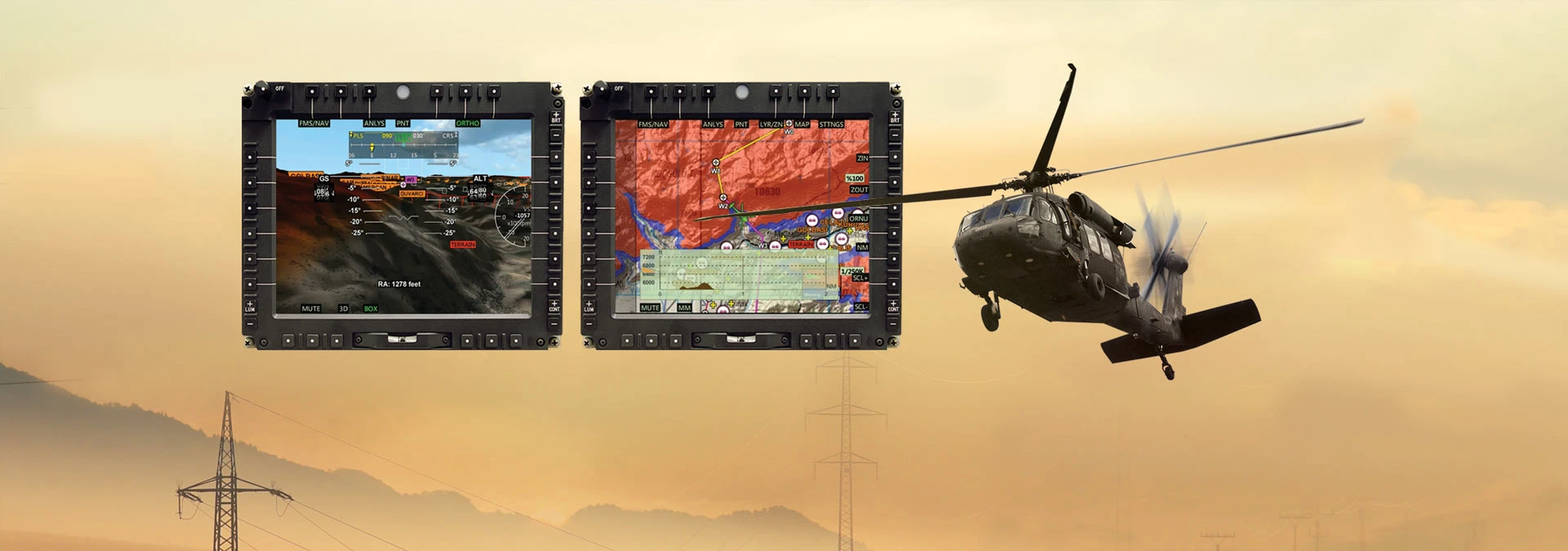
FocusFlite AS
Airborne Digital Moving Map System
FocusFlite® AS (Airborne Segment) is a moving map-based auxiliary system used to increase the situational awareness of pilots during their tasks on aerial platforms. The system's advanced human-machine interface, which has been created as a result of years of usability tests, dynamic content management and simplified user interface studies, maximizes effective use.
![]()
General Capabilities
- 2D moving map and 3D synthetic vision display modes
- True/Magnetic “North-up”, “Head-up” and “Track-up” map orientation modes.
- Vector layers and map coatings (user-defined points, buffer zones, country borders, territorial water borders, ACMAP/IAP/ ADC sketches, points of interest (POI))
- Information indicators (compass, HUD etc.)
- ARINC 424 and DAFIF navigation database display (airports, controlled airspaces, intersection points)
- Airways, navigation aids, tactical approaches, SUAS, FIR/UIR, NOTAM
- High resolution raster background maps (relief map, shaded maps, scanned maps: ortho photo up to the resolution of 1/ 25K, 1/ 50K, 1/ 100K, 1/ 250K, 1/ 500K, 1/ 1M, 1/ 2M, 2 Metres) Terrain Elevation Maps (DTED Level 4, 3, 2, 1 and 0)
- Various raster and vector map formats (CADRG, CIB, JPEG, Geotıff, Erdas Image, DDS, Shape etc.)
- User defined vector layers and styles
- Advanced CADRG format support for systems with capacity (disk and performance) limits
- Navigation and POI search capability that can be used in KDU supported systems
- Range and bingo circle display
- Multi language support
- UTM, MGRS, geographic coordinate systems and more than 50 datum
- Support for imperial/metric units
- True and magnetic north display
- Video recording
- Platform-specific data import and transfer mechanism
Real-Time Analysis Capabilities
- Vertical - Cross Section (VCS)
- Height Above Terrain (HAT)
- Line of Sight (LOS)
- Threat and Target Sight Unit
Applications
- Turkish Armed Forces ATAK Program (T129) and Gendarmerie Helicopter Modernisation Program (S70)
- Navigation and tactical military operations, patrol, civil aviation
Tactical Capabilities
- Display of obstacle, intelligence photos, threats, 2525B tactical drawing and military symbology, MAYDAY, location and situation report, observation report and close air support messages
- Weapon coverage, sensor data displays
- Flight plan and pattern demonstration
- Audible and visual obstacle, terrain, border and NOTAM warnings
- Tactical approach, flight messages, personnel locating systems (PLS), emergency checklist, off-the-route point and marked point
- HTAWS (Helicopter Terrain Awareness and Warning System) (DO-309/TSO C194 compliant and configurable.)
- Integrated with TerraFlite® (can work in non-GNSS environments)
Compatible Standards
- DO- 178B, DO- 257A, MIL- STD- 6017A, ARINC 424, MIL- STD- 2525B, MT76- 1A
Product Family Variants
- FocusFlite® AS High Performance Edition: It addresses high resolution, high refresh rate and high data display requirements on Windows/Linux RT (Real Time) platforms on powerful hardware.
- FocusFlite® AS Safety Critical Edition: It has been developed in compliance with DO-178B and OpenGL Sc restrictions to meet safety critical requirements. It is ready for DO-178B DAL C level certification and is supported by Greenhills INTEGRITY-178B RTOS as operating system.
- FocusFlite® Mobile Edition: It is designed for use on Windows/Linux platform tablets with touch screen. It can be used with STM AeroSuite® Solution.
Data Interfaces and Hardware Descriptions
- MIL- STD- 1553, ARINC 429, Ethernet, RS232
- COTS central and graphics processor units
- OPEN GL SC and GL 3.X support
Other Areas of Activities
While prioritizing Türkiye’s defense industry requirements, we diversify our technology-based operations to address the needs of both the public and private sectors, delivering innovative solutions across a broad spectrum.